Our AMTS Monitoring Services
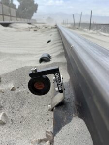
AMTS monitoring is an automated optical survey process used on construction sites to measure 3D angles and position data with motorized total stations. Sixense deploys high-precision AMTS equipment across a wide range of tunneling, excavation, rail, bridge, and geotechnical projects to track displacement at sub-millimeter accuracy, 24/7.
Cyclops, Sixense’s AMTS monitoring combines robotic total station instruments, survey prisms, and reflectorless points set at remote site locations with solar power, connected to cloud-based software. These automated monitoring technologies transform continuous field data into actionable reports, allowing project teams to identify changes without manual survey delays or field interventions.